At the moment an additional 50 houses within the village has been identified with the ‘potential sites’ shown in the Northern Parishes – Site Assessments. This will be in addition to the 50 allocated in the 2014 Plan which haven’t been built out (40 former Moorhurst site and 10 land South West Gould’s Drive) plus the currently unbuilt Michael Tyler site in the Hasting Fringes (40 houses) but is still part of Westfield Parish. These figures are laid out in the table below which is on page 135 of the draft Local Plan 2020-2040. The two lines relevant to Westfield Parish are ‘Westfield’ and ‘Woodlands Way and Parkwood Road (Westfield Parish).’
The table shows two figures:
- Identified Level of Housing Growth – Already identified sites from 2014 Local Plan
- Westfield – 50 houses identified (Moorhurst 40 and Gould’s Drive 10)
- Woodlands Way and Parkwood Road – 40 houses identified (Michael Tyler 40)
- Identified Level of Housing Growth – Already identified sites from 2014 Local Plan
- Westfield – 50 houses identified
- Woodlands Way and Parkwood Road – 0 houses identified
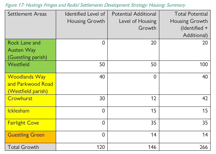
- Houses built out to date – 39 (Westfield Down 39)
- Total houses in Westfield Parish
- 39 houses built out already
- 90 houses already identified on sites across the Parish
- 50 additional houses for potential further growth
- Total = 179 houses 39 built out 140 to build
What Sites Have Been Proposed for Development in Westfield Parish
Existing Allocated Sites
Westfield Parish is in the 2014 Local Plan had the following sites allocated and these were reconfirmed in the 2019 Development and Site Allocation document (DaSA) and have also been included in the Draft Local Plan 2020-2040:
- Westfield Down policy WES1 in the DaSA (p260-261) – 39 houses – Built at 100% affordable (23 affordable rent and 16 shared ownership) instead of a 40/60 mix of affordable vs open market properties. This was contrary to the 2014 Local Plan and despite the Parish Council’s request to have 23 affordable rent with a split on the remaining houses to allow some open market properties Rother Planning Committee voted in favour for 100% affordable.
- Former Moorhurst site policy WES2 in the DaSA (p262-264) – 40 houses for ‘housing with care’ which required less garden space allowing a high density on this site 40% affordable – not built out. A planning application was put in RR/2021/3010/P for approval by the Rother Planning Officer for a large institutional style building for a 64 bed care home again contrary to the Local Plan. The Planning Officer stated the building had the potential to harm the High Weald National Landscape and the Drs Surgery stated very clearly that they could not cope with this extra demand. This was taken to Rother Planning Committee who voted for refusal for the 64 bed care home. However, it is likely the developer will appeal this decision which means until the appeal is concluded it is not confirmed.
- Land South-West of Goulds Drive policy WES3 in the 2019 DaSA (p264-265) – 10 residential units 40% are affordable – not built out. No recent planning applications have been submitted for this site.
Proposed Sites – Please note this site have been proposed by Rother Officers but have NOT been confirmed as the final sites and were not chosen by Westfield Parish Council
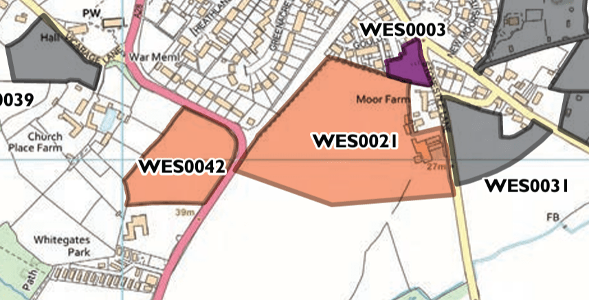
- Moor Farm, Westfield – WES0021 – Comments from Site Assessment from Rother Officers
- The site is within the High Weald National Landscape. Small area at risk of surface water flooding on northern boundary. Partly within two Archaeological Notification Areas. Historic field boundaries to east. Adjacent to Grade II listed building and public right of way.
- This is agricultural land on the southern edge of Westfield village. The site forms part of a larger field which extends to the south. In landscape terms, the site is more closely related to the wider countryside to the south than the built-up part of the village and there are long views from The Ridge in Hastings, although it is seen against the backdrop of the village. There could be an opportunity for development in the northern part of the site, with a new defensible village edge and a well-defined landscape buffer on the boundary with the countryside. Access needs further consideration. Initial comments of the Highway Authority suggest that while an access from the A28 could potentially be achieved, further details would be required, additionally, footway links to village services generally require improving. An access from the A28 would necessitate development in the southern part of the site which is less well related to existing development. The impact on the setting of the listed building to the east of the site, and the effects on the public footpath within the site, the narrow lane to the east, and the amenity of adjoining residents also require further consideration.

- Land on east side of Cottage Lane, Westfield – WES0040 – Comments from Site Assessment from Rother Officers
- The site is within the High Weald National Landscape and an Archaeological Notification Area. A public footpath adjoins its southern boundary.
- The site forms part of a larger area of agricultural land, just north-east of the main built-up area of Westfield. It is relatively close to services and public transport links in the village, although pedestrian connectivity is lacking. Access is via Cottage Lane, a narrow road with no footways. In principle, limited residential development could potentially be accommodated without harming the landscape or character of the National Landscape, subject to the provision of an appropriate landscape buffer to the north. A current planning application for 20 dwellings (RR/2022/1118/P) has not attracted an objection from the Highway Authority subject to improvements to pedestrian infrastructure, including a footway outside the site.
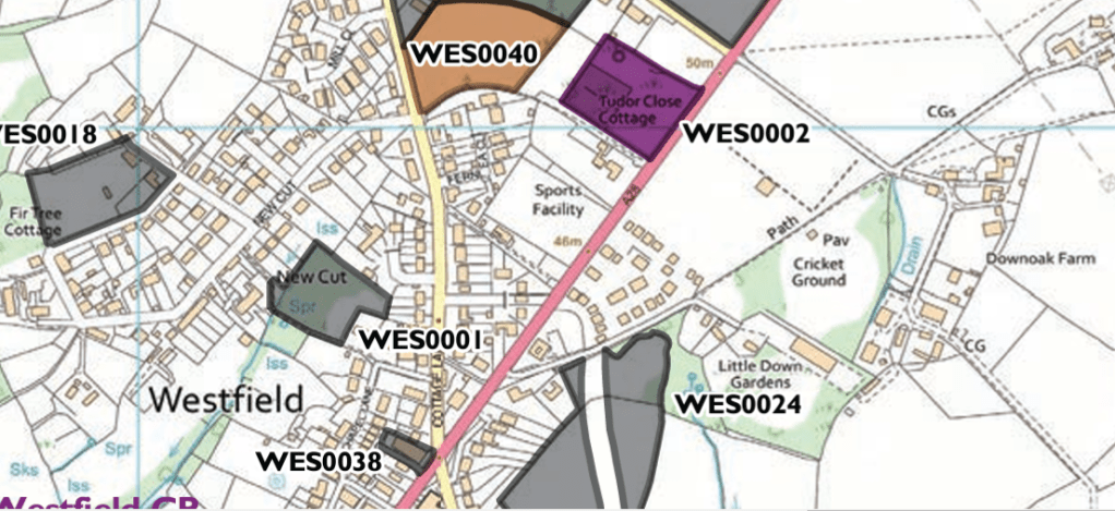
- Land west of A28, Westfield – WES0042 – Comments from Site Assessment from Rother Officers
- The site is within the High Weald National Landscape. Some risk of surface water flooding on adjacent road. Within an Archaeological Notification Area. There is a Grade II listed building nearby.
- h This is a relatively level field with a strong roadside hedge. It occupies a prominent location at an entrance to Westfield village and is highly visible from the adjoining main road and is also visible in long views from The Ridge in Hastings, although it is viewed against the backdrop of the village. It could potentially offer the opportunity for a small, highquality development including improved pedestrian infrastructure to the village. The impact on the landscape and setting of the village, together with the potential for safe access, require further consideration.
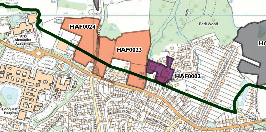
- Land east of Beaneys Lane, Hastings Fringes – HAF0023 and HAF0024 – Comments from Site Assessment from Rother Officers
- The site is within the High Weald National Landscape. Adjacent to areas of ancient woodland and Priority Habitat, some of which is subject to a Tree Preservation Order. There are areas at risk of surface water flooding in the east of the site and on the road to the west. There is a public footpath to the west.
- Together with nearby site HAF0024, these are fields on the northern side of The Ridge, lying partly within Hastings Borough. The site is within a sustainable location close to services and public transport links in Hastings, and is well related to existing development. This site has more tree and scrub cover than HAF0024 and it adjoins ancient woodland to the north-west and north-east, and there could be biodiversity constraints. In landscape terms, limited development could potentially be accommodated in the southern part of the site without harming the landscape or character of the National Landscape, subject to the provision of woodland and open space buffers to protect views northwards. Any development would need to protect the amenity of the adjacent, potentially sensitive, uses, including a care home. A mixed-use development could be appropriate across the two sites as the local area contains a mixture of residential, business and community uses. HAF0023 could potentially be more suited to residential (being closer to these uses) with HAF0024 for business (due to the proximity to Kings Church). Initial comments of the Highway Authority note that access via Beaneys Lane would not be suitable but a new access from The Ridge could potentially be gained, subject to further technical work. Note that the capacity of the site for HELAA purposes is limited to the section within Rother district.
There is also a long list of ‘Rejected Sites’ which can be found in the HELAA (Housing and Economic Land Availability Assessment) and a link to this document can be found below.
Please click onto the below links for more information:
- Main page for details on Draft Local Plan 2020-2040
- List of Events happening in the Parish in relation to the Draft Local Plan 2020-2040
- What is the Local Plan?
- What ‘Proposed Sites’ have been identified in Westfield Parish for delivering an extra 50 houses?
- Link to Rother District Council’s full Draft Local Plan 2020-2040
- Link to the HELAA (Housing and Economic Land Availability Assessment) for Westfield Parish. Please note that Westfield Parish has been split into two sections so you need to look at the maps for ‘Westfield – Hastings Fringes’ pages 48-52 and ‘Westfield – North’ pages 53-60
How to Submit Your Comments – Deadline for comments in 23rd July 2024!
- To submit your comments via the online form please click here.
- To download a printable PDF of the form please click here. If you are using the PDF you can submit your completed for via email to draftlocalplan@rother.gov.uk. If you wish to submit comments by post, please address correspondence to: The Planning Policy Team, Rother District Council, Town Hall, Bexhill-on-Sea, TN39 3JX. Please note that submissions made via post will not receive an acknowledgement that they have been received.
